truck trips a year
The City’s 2024 From Truck to Barge application said existing Red Hook Container Terminal operations already avoided this many trips on NYC streets.
The Blue Highway · Why all-port matters
A working waterfront for
New York’s future.
Our streets carry the deliveries, construction materials, and food a city needs. Our waterways can carry more of that load.
We support an all-port future for Brooklyn Marine Terminal (BMT): a modern, electric working waterfront that receives goods by water and sends them onward by water, with cleaner local deliveries and good-paying union careers.
Preserving all 122 acres gives New York room to build that future.
See the idea in under a minute
Blue Highways means using the harbor and rivers to move everyday goods. This animation by Zulu Associates makes the basic idea easy to see.
An illustration of the Blue Highways concept, not a depiction of an approved BMT project.
Goods travel in containers on a vessel, transfer at waterfront landing points, and continue to their destination. Our BMT proposal adds a clear community goal: keep suitable cargo on the water for as much of its journey as possible, then use clean, appropriately sized vehicles for the remaining local trip.
The model we want studied and delivered. Routes, equipment, and handling must fit each cargo and destination.
For a quick overview: Water in. Water out.—a seven-slide explainer based on Jim Tampakis’s ideas →
The reason to act is all around us
Every load that can move by water is an opportunity to ease the pressure on roads, bridges, and the neighborhoods beside them. Before shrinking BMT, study how much freight it could keep on the water.
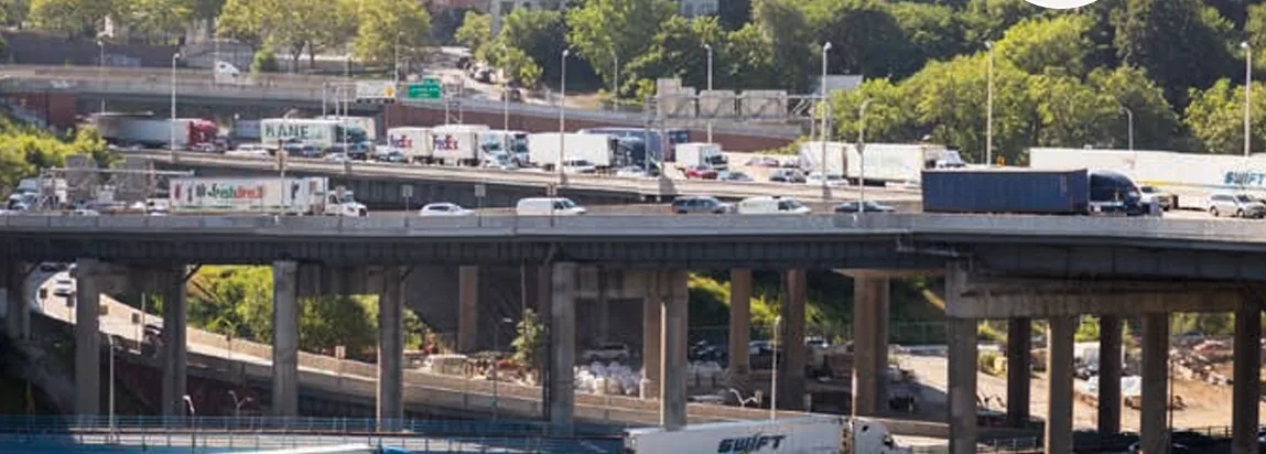
That question belongs in the BMT and BQE studies. Identify the cargo, routes, facilities, and waterfront space needed to replace truck trips.
BQE figures: NYC DOT · BQE Central project information ↗.
Make truck reduction part of your comment →Fewer trucks on our streets
In January 2025, THE CITY reported that each ship bringing lumber to Brooklyn replaces about 400 tractor-trailer loads on roads, bridges, and tunnels, according to Steven Packin, president of D&M Lumber Products, a BMT tenant.
The company had been squeezed onto one pier after two others were condemned. With too little room in Brooklyn, D&M was sending ships to Baltimore, Maryland, then moving the lumber back to New York by truck.
“If we had more space, we’d bring in more ships to Brooklyn. It’s as simple as that.”
Packin said his business was growing and needed additional space to expand. The demand was there. The waterfront space was the constraint.
Keeping room for cargo, warehouses, and cold storage at BMT gives more goods a direct route into New York by water—and keeps long truck journeys out of the supply chain.
The case is already in the public record
New York City Economic Development Corporation (NYCEDC) and the Department of Transportation (NYC DOT) have already made the case for shifting freight to water. Their findings should inform how much working waterfront we preserve.
The City’s 2024 From Truck to Barge application said existing Red Hook Container Terminal operations already avoided this many trips on NYC streets.
NYCEDC’s 2025 workforce study attributes this potential to Blue Highways investment by 2035, across the city—not at BMT alone.
The City’s Action Plan gives this range for aggregates and construction materials. The result varies with the cargo, vessel, load, and route.
The neighborhood test
For Columbia Street Waterfront, Red Hook, Cobble Hill, Carroll Gardens, Brooklyn Heights, and adjacent neighborhoods, supporting the port must go hand in hand with safer crossings, cleaner air, and better daily life.
The City’s Action Plan says about 90% of goods entering and leaving NYC travel by truck, with freight volume projected to grow 67% by 2045. Aging roads and bridges should not have to absorb all that growth. Read the City’s analysis ↓
Require electric cargo equipment, shore power, charging, and a funded transition to electric barges and other zero-emission vessels where feasible. Waterborne freight is not automatically clean; propulsion, energy supply, and actual operations matter.
Design onward water routes and reliable landing points. Use cargo bikes for suitable small loads and electric vehicles where needed. Heavy materials need different equipment and handling.
Set enforceable truck-trip and emissions targets. Publish truck counts, routes, idling, air-quality and noise data. Keep queuing and staging inside the terminal, protect pedestrian and bicycle routes, and correct problems when targets are missed.
Already on New York’s streets
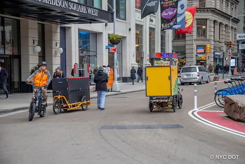
NYC DOT reports that cargo bikes delivered more than five million packages in 2022, making over 130,000 trips. These are practical tools for moving everyday goods through a crowded city.
The next connection is already being tested: in December 2025, the City launched a route from Atlantic Basin in Red Hook to Manhattan’s Pier 79, transferring parcels from NY Waterway ferries to DutchX electric cargo bikes.
Water in. Water out. Clean delivery for the last stretch. Give this network room to grow, with reliable waterfront hubs, sorting space, charging, and safe places to transfer goods.
NYC DOT · cargo-bike delivery results ↗ · See the Atlantic Basin–Pier 79 pilot ↗
Careers that support families
A working waterfront needs vessel crews, skilled trades, equipment specialists, freight coordinators, and people who keep the whole operation moving. Protecting the port protects pathways into that work.
Pair maritime investment with paid apprenticeships, local hiring, and paths into vessel operations, skilled trades, equipment maintenance, and logistics. NYCEDC’s workforce study recommends training access for NYCHA residents and a longshore apprenticeship program.
NYCEDC’s NYC’s Working Waterfront: A Blueprint for Blue Highways identifies 98 occupations across maritime work, transportation, logistics, and supporting industries. Its wage chart highlights these 20 priority occupations.
Hourly wages published in the June 2025 report. The median is the midpoint: half of workers earn more and half earn less. The 90th percentile marks the threshold for the highest-paid 10% in each occupation.
| Career | Median per hour | 90th percentile per hour |
|---|---|---|
| General and operations managers | $67.71 | $158.91 |
| Facilities managers | $65.38 | $106.13 |
| Ship engineers | $64.82 | $80.53 |
| Transportation, storage, and distribution managers | $60.68 | $98.12 |
| Captains, mates, and pilots of water vessels | $44.23 | $71.49 |
| Sailors and marine oilers | $30.68 | $47.46 |
| General maintenance and repair workers | $27.27 | $42.93 |
| Cargo and freight agents | $27.03 | $38.55 |
| Laborers and hand freight, stock, and material movers | $22.18 | $33.70 |
| Driver/sales workers | $18.11 | $29.77 |
| Management analysts | $55.68 | $129.49 |
| Logisticians | $45.10 | $72.30 |
| Bus and truck mechanics and diesel engine specialists | $37.18 | $47.10 |
| Transportation and material-moving supervisors, except aircraft cargo handling | $32.51 | $51.18 |
| Heavy and tractor-trailer truck drivers | $26.90 | $51.77 |
| Shipping, receiving, and inventory clerks | $23.18 | $34.09 |
| Light truck drivers | $21.58 | $46.72 |
| Automotive service technicians and mechanics | $21.44 | $35.88 |
| Stockers and order fillers | $20.59 | $28.74 |
| Couriers and messengers | $17.73 | $41.27 |
See the City’s original wage chart · printed pp. 58–59 ↗ · Explore the full occupation list · Appendix A ↗
Union careers have negotiated wage ladders. The same report highlights the International Longshoremen’s Association’s six-year agreement, raising the top base wage from $39 to $63 an hour over the contract term.
Our demand is to connect this opportunity to local people: paid apprenticeships, strong union standards, affordable training, and clear routes into skilled and licensed careers.
See what other waterfronts make possible
Brooklyn and New York City deserve a world-class working waterfront, with public access wherever possible. Welcoming people to the harbor can be part of protecting its working future.
Waterfront Alliance’s Integrating Industry and Public Access for a Sustainable Future documents practical examples in the United States and abroad. These photographs show how paths, overlooks, and education can bring people closer to maritime life.
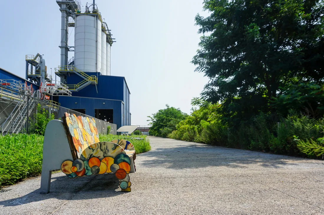
Bronx, New York
Oak Point / McInnis Cement combines ship-delivered cement with a public walkway and neighborhood art. The path also supports drainage, site security, and emergency access.
The lesson for BMT: Design one space to serve neighbors and port operations.
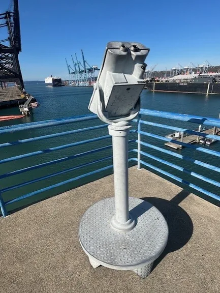
Tacoma, Washington
The observation tower at One Sitcum Plaza gives visitors a safe view of container terminals, ships, and the Sitcum Waterway. Signs help explain the port and its jobs.
The lesson for BMT: Let people see and understand the working port.
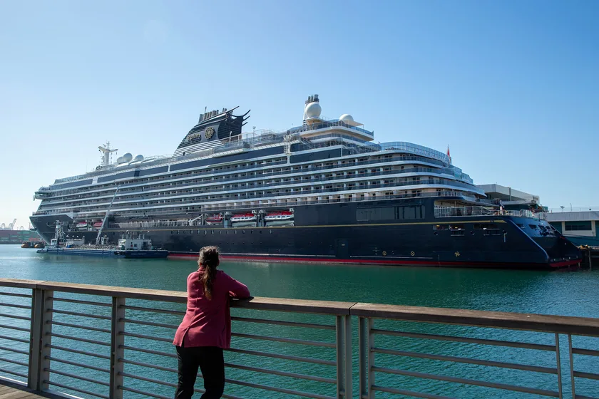
Los Angeles, California
The Cruise Ship Promenade welcomes people beside the port’s cruise operations, with places to walk, sit, and watch vessels and activity across the channel.
The lesson for BMT: Make the waterfront experience part of a functioning port.
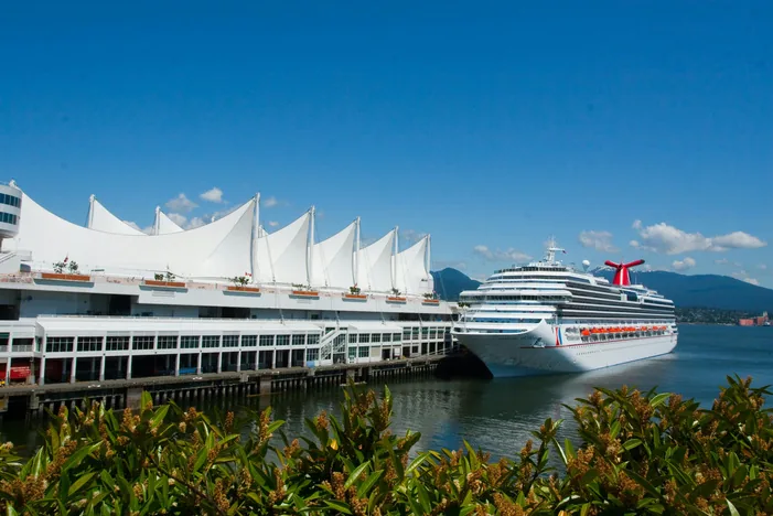
Vancouver, Canada
Canada Place pairs an active cruise terminal with a public promenade. Its Port of Vancouver Discovery Centre uses exhibits to connect visitors with maritime trade and the working harbor.
The lesson for BMT: Combine public access, education, and maritime activity.
Ask for accessible waterfront paths where they fit, safe overlooks, places to sit, port tours, and maritime learning spaces. Design public routes separately from cargo handling and truck movements, with clear access, maintenance, and safety commitments.
New York’s own waterfront plan supports public access on City-owned waterfront sites alongside compatible working uses. Public access should help people experience and value the port while preserving the space it needs to work.
Read the City’s public-access policy ↗ · Explore all the Waterfront Alliance case studies · PDF, 27 MB ↗
What this could make possible
All-port means a productive working waterfront serving the city and region: goods, careers, essential supplies, and space to adapt. These are opportunities to study and develop with workers, operators, and communities.
Keep food fresh, sort everyday parcels, and connect them to waterborne delivery routes. These services need cold storage, handling space, and reliable links between waterfront hubs.
See the ferry-to-cargo-bike pilot
Keep the cold-storage commitment →Study waterborne lumber, aggregates, building components, and equipment. Test room for staging and selected assembly, including the needs of BQE rehabilitation. A working port can help New York build beyond the terminal’s boundaries.
Build backup freight routes into New York’s emergency planning. Preserve waterfront access, space for essential supplies, reliable power, and flood protection so BMT can help keep the city supplied through disruptions.
Waterborne routes and supply-chain resilience · printed p. 20
Why backup routes matter ↓Think beyond Brooklyn
A modern BMT can serve all five boroughs and connect New York City with the Hudson Valley, Albany, and Long Island. Water in, water out is a regional opportunity.
Across the harbor
The City’s Truck-to-Barge proposal identifies BMT connections to Hunts Point, Manhattan, and Governors Island, with freight moving in both directions. Food, construction materials, and packages can travel by water, then connect to cleaner local deliveries.
North on the Hudson
The federally designated M-87 Marine Highway connects New York Harbor with Hudson River ports and Albany. BMT can be a city gateway for goods moving along this water route.
East through the Sound
The M-295 Marine Highway runs from New York Harbor through the East River, Long Island Sound, and Block Island Sound. It opens a waterborne path to Long Island waterfront destinations and the wider region.
Every highway needs entrances and exits
A Blue Highway works through waterfront “nodes”: places where goods arrive, transfer, and continue toward their destination. BMT can connect larger shipments to a network of smaller neighborhood landings.
25 waterfront locations assessed
Explore the City’s map of potential Blue Highways sites and the waterfront connections around BMT.
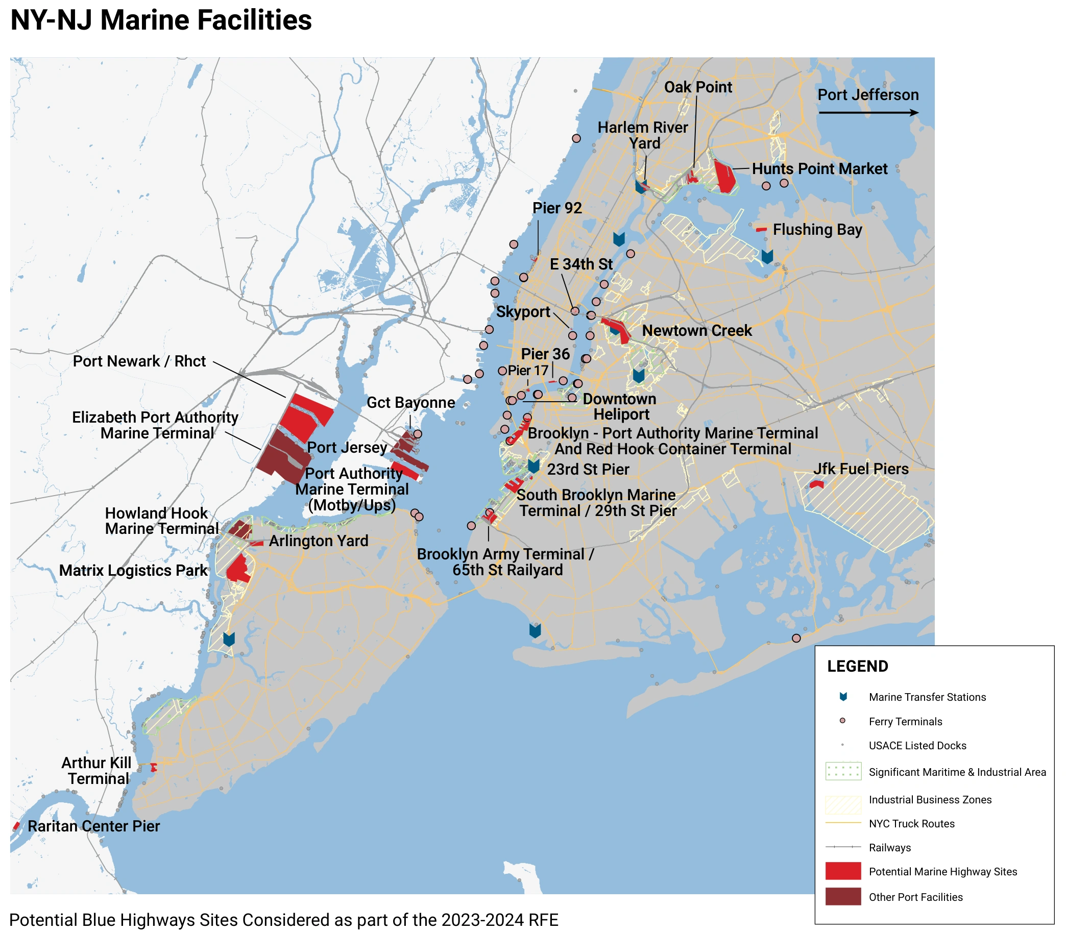
Map: NYC Department of Transportation and NYC Economic Development Corporation, Blue Highways Action Plan, October 2025. View the original map · printed page 40 ↗
Receive larger loads. Sort and store goods. Keep food cold. Load smaller vessels for the next waterborne leg.
Water in. Water out.Examples of locations assessed in the City’s Action Plan.
Transfer suitable deliveries to electric cargo bikes and clean local vehicles. Match each landing to the neighborhood and the goods it can handle.
The City assessed 25 waterfront locations. It found that BMT could accommodate every Blue Highways service category with appropriate improvements. A network needs both smaller landings and a capable hub with room to grow. See the assessment, map, and site table · printed pp. 39–41 ↗
Why we support all-port
Water in, water out still needs a place in between: to unload, sort, refrigerate, store, assemble, charge equipment, and transfer goods. Those functions compete for space.
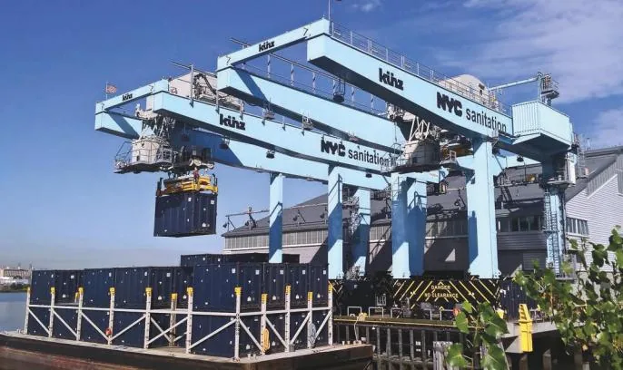
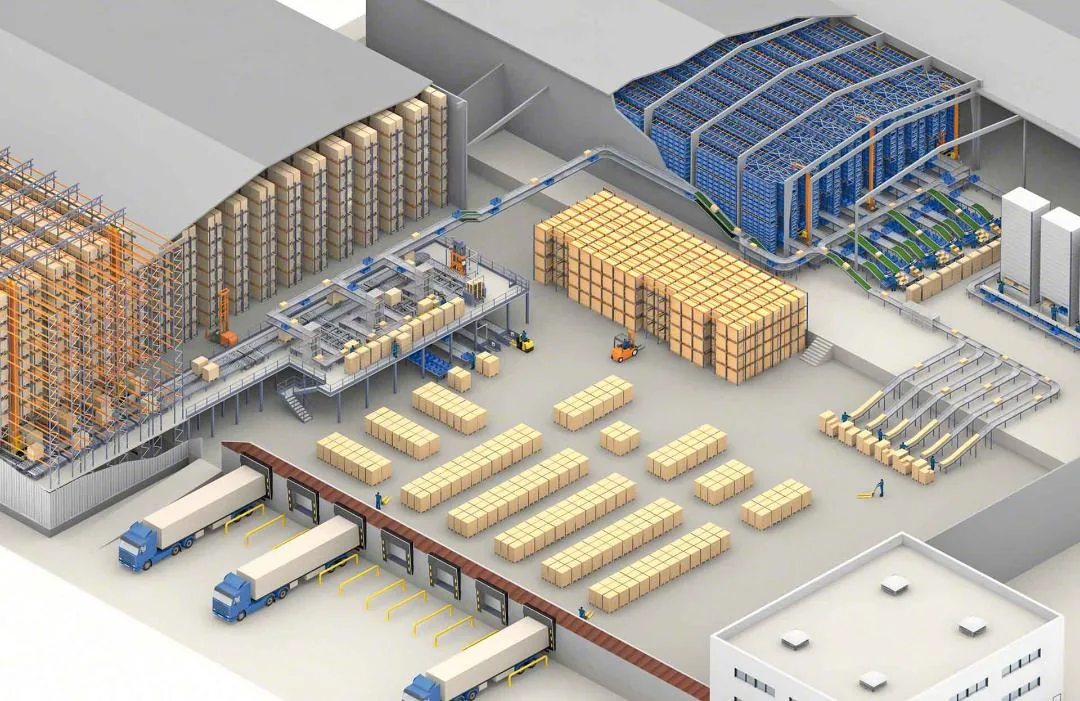
Our position is that limiting port uses to 60 acres constrains what this waterfront could become. Container operations are one part of the picture. A full alternative should test cold storage, parcel sorting, building-material handling, marine services, training, emergency logistics, and space for future demand.
BQE construction staging also needs to be considered alongside everyday port operations. Reserving land for temporary construction can affect what is available for long-term freight work.
NYCEDC says its proposed 60-acre layout can accommodate container growth, bulk cargo, construction staging, and a barge connection to Hunts Point. We are asking for a transparent comparison with all 122 acres: which activities fit, which are displaced, and what future opportunities are lost?
NYCEDC’s 60-acre layout and staging explanation · pp. 6–7
The City Club of New York also challenges the reduced footprint, arguing that the Blue Highway needs a full maritime hub with storage, distribution, and vessel services. Read the City Club’s alternative and reasoning ↗
An all-port study should measure the public benefits across the city and region, alongside operating costs and revenues. The available evidence supports studying that choice; it does not establish a precise minimum acreage for every possible use.
Why this waterfront is special
BMT brings together vessel access, piers, warehouses, and working land close to the city’s customers. It sits within two areas New York identified to support industrial and maritime activity.
BMT lies within the Southwest Brooklyn IBZ. These zones support industrial businesses, investment, and good jobs. NYCEDC describes a City commitment not to support new residential rezonings in IBZs.
Read the City’s IBZ policy ↗ · See the Southwest Brooklyn map ↗
BMT is within the Red Hook Container Terminal SMIA. The City’s Waterfront Revitalization Program gives industrial and water-dependent uses priority in these areas and calls for protecting their safe, efficient operation.
This commitment goes back decades. Mayor Michael Bloomberg’s 2005 industrial policy pledged not to rezone IBZs for housing. Read the original policy ↗
The 2021 NYC Comprehensive Waterfront Plan calls for preserving industrial space, discouraging residential rezonings in IBZs, modernizing piers, and building a network of freight hubs served by water. Read the City’s waterfront strategy ↗
Our demand: apply those priorities at BMT. Invest in a world-class working waterfront. Study the full 122-acre all-port alternative before permanently giving up the space the Blue Highway needs.
Waterfront Alliance also called for a 50-year assessment of BMT’s maritime needs before industrial land is repurposed, including port capacity, truck traffic, emissions, and supply-chain resilience. Read its BMT recommendations ↗
Turn the opportunity into a public commitment
All-port is our goal. Port-first is the minimum. Protect the existing working waterfront while a fair, fully costed 122-acre alternative is studied.
Ask officials to compare water in, water out freight, cold storage, union career pathways, construction logistics, emergency readiness, and compatible public access—with enforceable neighborhood protections.
Read it for yourself
Start with the Action Plan for the citywide strategy, the grant application for the City’s original BMT case, and NYMTC for the regional perspective. Source descriptions distinguish forecasts, earlier proposals, and community alternatives.
The City’s BQE traffic figures: approximately 130,000 vehicles daily, including 13,000 trucks. Project information checked October 1, 2026.
EDC’s account of the Red Hook–New Jersey–Hunts Point food route and the role of cold storage.
March 27, 2024. NYC DOT’s reported 2022 package deliveries and trips, alongside the City’s cargo-bike rules.
NYCEDC + NYC DOT · October 2025. Read printed pp. 10, 17–22, and 26–36 for freight patterns, benefits, services, and infrastructure; pp. 39–41 assess 25 waterfront locations.
NYCEDC · June 2025. Citywide workforce forecasts and career pathways. The wage chart is on printed pp. 58–59 (PDF p. 30); Appendix A lists 98 occupations. Read the shorter findings summary .
City of New York / NYCEDC · 2024 grant application, FY25–26 program. Archived original, 6-page PDF, 334 KB. This is the project-description component, not the entire application package. Its scope and estimates precede the later redevelopment vision.
Adopted September 5, 2025 · Appendix D. BMT and marine highways: printed pp. D-129–D-131 (PDF pp. 134–136). Large PDF, about 70 MB. Browse the complete plan .
NYC DOT · December 11, 2025. An operating pilot showing how a water leg can connect to local electric cargo-bike deliveries.
Public Workshop 4 FAQ · responses as of March 24, 2025. The City’s case for its 60-acre layout and its acknowledgment of truck impacts; earlier planning assumptions require testing in environmental review.
A community-supported maritime alternative for consideration alongside the City’s redevelopment proposal.
Reporting by Samantha Maldonado / THE CITY, republished in Queens Daily Eagle, January 9, 2025, printed p. 10. An operator’s account of lumber shipments and diversion to Baltimore.
U.S. Maritime Administration · December 2025. Official route description and map linking New York City, Hudson River ports, and Albany.
U.S. Maritime Administration · December 2025. Official route description and map from New York Harbor through the East River, Long Island Sound, and Block Island Sound.
Waterfront Alliance interview · September 17, 2020. Working-waterfront careers and economic opportunity.
Official remarks · April 3, 2025. The Kill Van Kull, Baltimore’s bridge collapse, and the case for Brooklyn port capacity. Read his July 24, 2025 remarks ↗.
The City’s framework for industrial space, freight hubs, climate resilience, and compatible public access. Economic opportunity ↗ · Public access ↗
Official coastal policy for Significant Maritime and Industrial Areas, including the Red Hook Container Terminal area.
NYCEDC’s IBZ policy and support for industrial businesses. Southwest Brooklyn IBZ map ↗
The Bloomberg administration’s industrial policy, including its commitment concerning residential rezonings in IBZs.
October 2024 · Case studies from NYC and around the world, including the photographed examples above. PDF, about 27 MB.
November 21, 2024 · A call for a 50-year maritime-needs assessment before repurposing industrial waterfront land, and public access compatible with port operations.
An international example of public views and education at a working port. Opened in March 2025.
We move forward together
Bring your concerns, your ideas, and your skills. There is a place for you in this work.